Even at current sea levels, a flood with a one-percent annual chance of occurring in South Boston could impact 60 buildings and around 1,000 people, causing up to $140 million in damage. With an expected nine inches of sea-level rise by the 2030s, the same flood could impact 2,500 people and do $1.2 billion in damage. By 2070, when the sea level is projected to rise by as much as 40 inches, more than 40,000 people would be exposed, and the flood could do more than $8 billion worth of damage.
And that’s just South Boston.
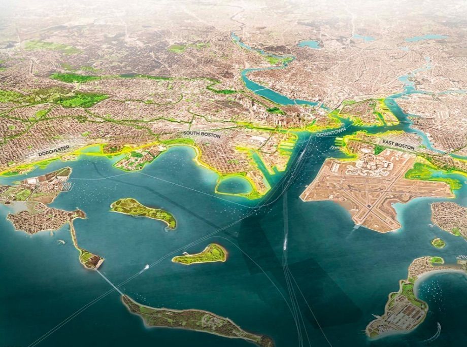
Last week, Boston Mayor Martin Walsh announced the broad outlines of a plan to knit together climate-change adaptation strategies along 47 miles of waterfront to create a “Resilient Boston Harbor.” The plan involves creating elevated landscapes to manage flood waters along the waterfront, protecting residents and businesses further inland while providing more public access to the harbor.
The harbor plan follows the city’s Comprehensive Resilience Plan, released last year. The comprehensive plan lays out a broad definition of resilience, envisioning a city that can respond to its “most serious shocks, such as extreme weather events, and [its] chronic stresses, such as economic inequality and aging infrastructure.” It aims to make racial equity a priority in all of the city’s efforts, prioritize community-led planning, create “intergenerational wealth-building opportunities” for all of the city’s residents, and connect Bostonians with climate-resilient infrastructure.
Christopher Cook, the city’s Chief of Environment, Energy and Open Space, says the primary aim of the resilient harbor vision is to unify a series of neighborhood-level plans that are already underway. Specific projects include adapting buildings for expected sea-level rise, creating elevated berms — a type of raised barrier, restoring natural salt marsh areas, renovating parks, and creating new public spaces, with programming to serve a range of communities.
“As we move into these resilience projects, we’re not interested in just creating wonderful waterfront playgrounds that are playgrounds for the rich,” Cook says.
The plan includes efforts to preserve some existing affordable housing near the harbor, with the potential to create new affordable housing as part of mixed-use redevelopment projects at a few key sites in the waterfront area, Cook says.
“Those projects that have the most opportunity to either enhance or solve for socially vulnerable populations, those have to be invested in first,” he says.
The mayor’s choice of venue to announce the resilient harbor plan—his annual speech to the Greater Boston Chamber of Commerce—was strategic. During the speech, Walsh announced that the city would commit 10 percent of all new capital budget to resilience projects. But it will also need much more money to carry out all of the planned interventions. The city is applying for a pre-disaster mitigation grant from FEMA, Cook says, and seeking investments from philanthropic foundations as well. And it hopes that some waterfront property owners will expand their resilience investments beyond their own buildings to help protect the entire landscape.
“The waterfront is an amalgam of public, private, and institutional landowners,” says Kate Orff, founder and principal of SCAPE, the landscape architecture firm hired to help create the unified harbor plan. “So what’s key about this is, I think the mayor is trying to get in front of the change process, inspire those conversations and try to get the public and the private sector in alignment and working towards a shared goal.”
By the time SCAPE was hired, a lot of climate planning had already been done at the neighborhood level. The firm’s job was to synthesize those plans —“Water doesn’t follow neighborhood boundaries,” says SCAPE principal Alexis Landes — and create a unified vision for resilience at the scale of the harbor.
“We are kind of providing this glue or a fabric that pulls these things together,” Orff says. “What we’ve heard from many in the Boston area is that neighborhood-based planning and the strength of Boston’s neighborhoods is an incredible asset, and neighborhoods themselves are quite strong, but looking to the future there has to be more connective tissue that pulls the neighborhoods together.”
The firm’s illustrated maps show the waterfront highlighted with bright green where elevated landscapes are envisioned, and tracked with pink lines to show new paths to public waterfront access. Earlier this month, an exhibit opened at the Boston Public Library pairing works of contemporary with maps of Boston throughout the city’s history. The maps show an unfolding reinvention of the city, Orff says, and she hopes the harbor plan makes a contribution to that process.
“We were hoping that these drawings would be read in that same vein,” Orff says. “Helping to create an imprint and a perception change in the minds of Bostonians to be able to help forge this new relationship with the water and each other, and really kind of set that new template for a change process.”

Jared Brey is Next City's housing correspondent, based in Philadelphia. He is a former staff writer at Philadelphia magazine and PlanPhilly, and his work has appeared in Columbia Journalism Review, Landscape Architecture Magazine, U.S. News & World Report, Philadelphia Weekly, and other publications.
Follow Jared .(JavaScript must be enabled to view this email address)

