An abandoned home sits between two elevated houses. (Photo by Aminah Ghaffar / Southerly)
This is your first of three free stories this month. Become a free or sustaining member to read unlimited articles, webinars and ebooks.
Become A MemberThis article first appeared on Southerly and is republished here under a Creative Commons license. It was written as part of the publication’s Community Reporting Fellowship.
It’s been more than five years since Robeson County, the largest in North Carolina, was devastated by two 1,000-year floods. Hurricanes Matthew in 2016, and Florence, in 2018, caused more than $21.8 billion dollars in total damage, destroying hundreds of homes. Despite $2.8 billion in state and federal funding allocated for disaster relief, many homes are abandoned and residents have either moved away or are still waiting for more to be rebuilt.
One of the groups combating what they see as the neglect of Robeson County is Robeson County Cooperative for Sustainable Development (RCCSD). Since 2019, the nonprofit has done advocacy and community organizing, and hosted “Disaster Survival Tours” that take residents, elected officials, and other groups on a journey through the aftermath of the storms. They hope politicians might better understand the need for sustained aid, and that locals can see how they can help their neighbors return home.
Robeson County is home to a unique socio-political landscape. The homelands of the Lumbee Tribe of North Carolina are within its borders and the demographic makeup is diverse; it’s 44% Native American, 23% Black, and 29% white. As storm response drags on, some longtime residents worry that the Lumbee tribe and Tuscarora Nation, as well as Black residents — the most affected by the storms — will be displaced.
People living in impacted neighborhoods are concerned about the future: will neighbors return, or will they continue to look at empty houses and abandoned streets? Will the next storm leave their house vacant, too?
In December, RCCSD took me on a disaster tour of landmarks that bear the scars of the storms’ damage. The first stop was the intersection of VFW Road and Crystal Road in Lumberton, the county seat, in a neighborhood of predominantly Black and Indigenous residents. It sits at the corner of Luther Britt Park and Interstate 95, and during Matthew, this area was completely underwater, with nearby railroad tracks submerged and I-95 impassable.
The highway became part of the Lumber River — also called the Lumbee River or Drowning Creek — which is the main body of water that runs through Robeson and surrounding counties.

The intersection of VFW Road and Crystal Road by the I-95 overpass. (Photo by Aminah Ghaffar / Southerly)
“If you look at the demographics of Lumberton, low wealth and racially marginalized communities predominantly live on [the low] side of the river,” said Dr. Ryan Emanuel, a Lumbee hydrologist and environmental activist. “That’s the same pattern repeated in a lot of cities in eastern North Carolina, where the older, whiter and wealthier neighborhoods are on the high side of the river.”
The levee worked for about 50 years, until Hurricane Matthew hit. On October 8, 2016, the river was already cresting when the storm brought more than a foot of rain. Water rushed over the levee, flooding churches, schools, and neighborhoods. Then, in 2018, Hurricane Florence dropped 23 inches of rain in the same area, leaving homes, schools, and businesses inundated.
The railroad track runs under I-95, which is part of the levee, making a gap in the levee. If water gets high enough, it can flow through—which is what happened during Matthew and Florence. FEMA was aware of the potential for catastrophic flooding through the railroad tunnel before the hurricanes but inaction by the rail owners, CSX, led to delays in addressing the problem. Since 2018, the city of Lumberton has been trying to move forward a plan to mitigate flooding and plug that gap by installing a moveable gate over the railroad track.
The new floodgate would close when the river rose, effectively sealing the hole. The project currently has about $5 million in funding from the N.C. Golden Leaf Foundation, federal grants and local matches, but the final cost is still unclear.
Robert Armstrong, Lumberton’s director of public works, said the floodgate would enhance the existing levee system and keep water from reaching West and South Lumberton neighborhoods. “What we experienced in Hurricane Matthew was much more extreme flooding [than when the levee was built in the 1970s] to where it was about six to eight feet higher than the railroad track,” Armstrong said, “and again in hurricane Florence it even went higher.”
But the floodgate stalled when the state transportation department announced a $430 million project to widen and elevate I-95 and lengthen the bridges over the Lumber River. The bridges will be about 10 feet higher and the road will rise by around one to 10 feet, allowing interstate travel to continue even if the river swells.
Michael Parker, resident engineer for the North Carolina Department of Transportation said I-95 is a “vital corridor in our state, and also a hurricane evacuation route.”
“Our department has adopted a policy to improve our procedures, road planning and maintenance with an eye toward making our infrastructure more resilient to changing weather patterns,” Parker said. “Reconstructing I-95 with resiliency in mind and to better withstand future flooding has increased our construction costs for this project by 11%.”
With this plan taking precedent—scheduled to be completed in summer 2026—work on the gate for Lumberton residents is on pause.
Parker said it’s a necessary process. “I’ve lived in Lumberton my whole life. Hurricane Matthew and Hurricane Florence were truly horrific events to live through in southeast North Carolina,” he said. “We’ve never seen anything like that before, and I hope I never do again.”
He added that they are “improving everything. We’re raising the bridges, widening the road and we’re improving the drainage to hopefully minimize any issues in the past.”
But Brandon Love, Deputy City Manager of Lumberton, says even with new infrastructure in place,“it’s going to keep raining, and we are going to keep flooding.”
Emanuel said that no project, however well considered, can change the reality of the floodplain.
“People have studied this phenomenon for decades, by raising levees, strengthening flood walls, and hardening all of this flood infrastructure,” he said. “We know time and time again that it can increase the vulnerability of people in that whole area, because more and more people come to rely on that flood protection infrastructure for their safety during times of flood.”
Historically, Indigenous communities in this area would only camp in floodplains temporarily during dry seasons. Today homes stay rooted in one place, making it more difficult to live in harmony with the floodplain. “[Indigenous] culture teaches us that it should not be a competition in the first place,” he said. “We have to figure out a way to respect nature by living responsibly alongside it, instead of setting up this competition between people and nature.”
But he acknowledges that it’s complicated. “We can’t force everybody out of the homes that they built over the past 50 years, but we do have to address the problem, and we need to do it equitably.”
Elected officials, concerned citizens, and ancestral occupants are searching for balance between keeping historical communities intact while also prioritizing safety. Matthew and Florence have influenced a recovery plan that seeks to determine changes in the floodplain, how to live in harmony with the floodways, and a holistic recovery and resilience strategy to minimize flood impact. This project seeks to identify the most vulnerable areas in the floodplain so people can decide whether to move or rebuild. But that would mean multiple municipalities and county governments would have to come together to look at the floodplain holistically.
“We need to be open minded to the different avenues toward living in harmony with the floodplain. What’s always been done might not always be the best way,” said Hannah Jeffries, a community organizer with RCCSD. “We have to be adaptable and more collaborative with nature.”
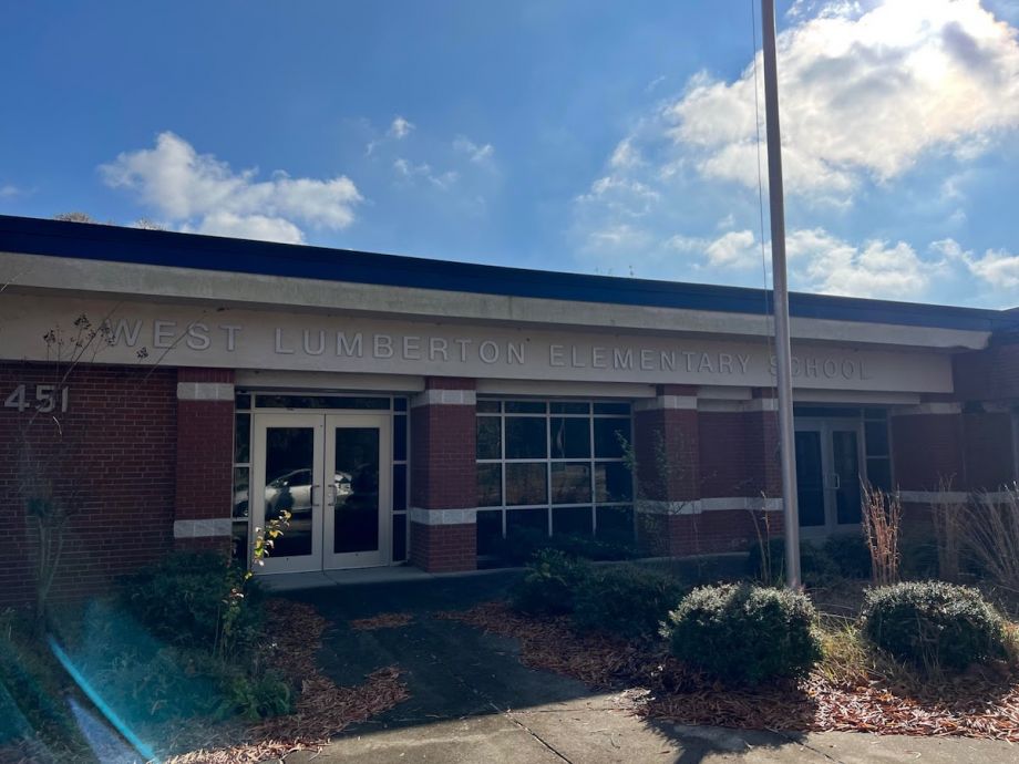
Mac Legerton, RCCSD co-director, drives just a few minutes to the second stop on the tour: the abandoned West Lumberton Elementary School. Hurricane Matthew pummeled the school, and the damage, combined with a major population drop after the storm, led the Robeson County school board to close it permanently in 2018 despite parents’ objections.

The abandoned West Lumberton Elementary School. (Photo by Aminah Ghaffar / Southerly)
“[The students] lost their friends, their schools, and their churches,” said Sallie McLean, co-director of RCCSD. “A lot of them internalize it and don’t understand it.”
Jeffries is interested in addressing the emotional and physical impacts of the storms. “What this school shows me is the loss of innocence, and the loss of us being able to prepare for the next generations after us,” she said. “As an Indigenous person, we believe in the teaching of the Seven Generations: all of our actions will influence the next seven generations after us.”
Most of the students at West Lumberton were Black and Native American. For Jeffries, the school bears a generational curse that must be broken by rebuilding a sustainable and thriving community.
Storm infrastructure projects and aid for rebuilding community assets, like schools, may help in that goal. But the storms caused a housing crisis, too—a major reason the school’s population dropped in the first place.
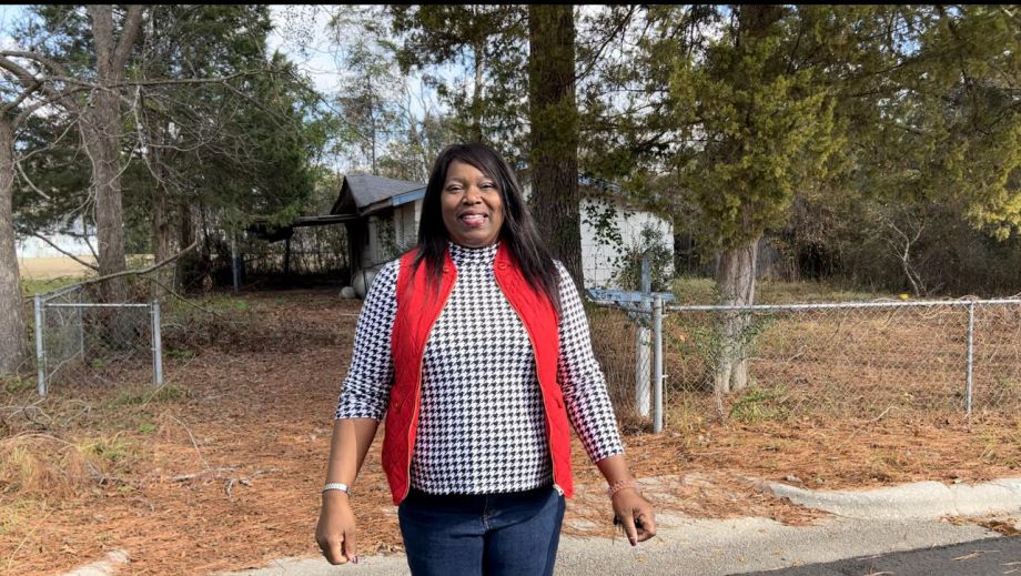
To demonstrate, the guides lead me to a South Lumberton neighborhood with several abandoned houses. Carol Richardson, an RCCSD member who helps lead the tours, remembers her childhood as she stands in front of one of them. Her aunt and uncle once lived there. During Matthew, they evacuated by boat. As she checks out the empty street, she describes her childhood spent with cousins. The block was full and joyous before the hurricane.

Carol Richardson in front of her aunt and uncle’s abandoned home in South Lumberton nestled near Luther Britt Park. (Photo by Aminah Ghaffar / Southerly)
In 2022, a new sensory park opened nearby, but Richardson said it goes largely unused.
“It’s an ugly situation and heartbreaking, because you grew up in that community,” McClean said. “All your children, and your grandchildren were there, and now your legacy is gone.”
While immediate disaster relief programs from FEMA have long expired, some Lumberton homeowners impacted by the storm still have two options for aid: reconstruction through elevation or acquisition by the state. State acquisition is a voluntary program that allows home loss victims within designated buyout zones to choose to sell their homes to the state at current appraised market value. Once the home is sold, it is demolished and managed as green space.
According to RCCSD’s 2020 West and South Lumberton Census data analysis, 31% of homes in Lumberton, a town of about 18,700 people, are unoccupied. Martin Luther King Drive splits West and South Lumberton on the two Census tracts. East of MLK Drive, 35% of homes are dilapidated, and West of MLK Drive the vacancy rate is 28%.
Some of those homes were already abandoned and dilapidated before the storms, but data suggests that Hurricanes Matthew and Florence exacerbated the housing problem in the area.
Some Robeson County residents are concerned about community preservation and encourage their neighbors to rehabilitate and elevate homes. The ReBuild NC Homeowner Recovery program is supposed to assist homeowners in reconstructing their properties to better withstand future disasters. However, as NC Policy Watch extensively reported, ReBuild NC, formally known as the NC Office of Recovery and Resiliency, is plagued with problems: some homes already built are falling apart, and many applicants are still waiting due to troubled contractors and construction delays. For instance, in Robeson County, hundreds of families are waiting to return home while ReBuild is taking credit for the county’s local program, according to the investigation.
Not everyone will have a choice about how to proceed with their property. Federal and state policies impose restrictions: No new construction is allowed on flood-prone land and property owners for whom the cost of rebuilding a damaged home exceeds 50% of the structure’s value may not receive permits. That can send people seeking new housing somewhere else entirely.
RCCSD is now working to figure out where people are in this process and where disaster survivors are going. Legerton hopes that will help them better understand what the community needs.
“Something needs to be done to address these homes from either being torn down and being unable to rebuild,” Hannah Jeffries added. She’s concerned about the future of home ownership for young adult residents like her. “We’re coming of age. We want a new home, something that’s going to be ours. If they keep tearing down a lot of these homes, then what will we have left?”
Some homes have been repaired, whether using FEMA grants, or through city initiatives and nonprofits’ assistance. But with thousands of structures affected between the two storms, the majority of homes remain on the backlog.
The next stop on the tour is in a less affected part of town between South and West Lumberton, where homes are still neatly maintained and occupied. RCCSD has street leaders, which are neighborhood residents willing to be a resource to their communities.
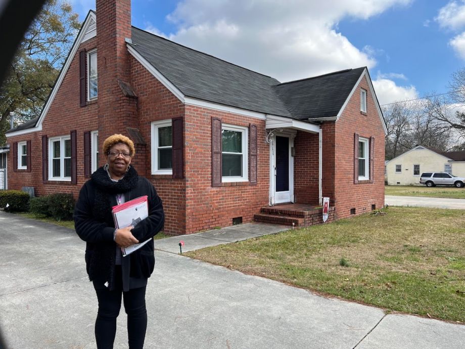
“Being a street leader, I have noticed my home was not impacted as much,” said resident Monique Sessoms. She had to evacuate during Hurricane Matthew, but returned to relatively mild damage. She’s working to care for the neighbors that remain and to make a safe return possible for those that left, too.

Monique Sessoms, a street leader, in front of her home in South Lumberton. (Photo by Aminah Ghaffar / Southerly)
“The reason we wanted to start this initiative is that we are forming closer communities,” Jeffries said.
Emergency management becomes more efficient, she added. “There is someone who has a contact list so we can double check homes. So many people were displaced with Matthew, there was no system in place to figure out who is still in the home, what medical conditions they have, or if they are disabled,” she said. “This is a way to combat displacement and loss of life during the storms.”
The tour wraps up near McCormick Chapel AME located in South Lumberton, a historically Black church that’s hosted some of RCCSD’s community meetings, which bring out dozens of people to share their needs and ideas for hurricane preparedness.
“I hope this work encourages more young people to get involved and to understand the system as it is now, the pitfalls of that system, and how to create new ideas to improve it,” Jeffries said. “True systematic change is what we are trying to achieve, and that is only going to happen with people of all ages and backgrounds contributing their knowledge and life experiences.”
That kind of change takes time. Meanwhile, hurricane season is less than four months away.

20th Anniversary Solutions of the Year magazine