Azavea is an award-winning software development, analysis, and visualization firm that applies geospatial technology for civic, social, and environmental impact. As a certified B-Corp, they use maps and geographic data to help people make better decisions. Learn more.
Curb management is becoming a hot topic for cities as street users compete for the often overlooked resource. Many books (like this and that) have been written about parking. Companies are forming to enable improved access to parking and parking data. Cities are publishing reports about their curb management strategies (San Francisco’s). Data standards are being created to improve digital coordination.
Azavea had a great opportunity to dive into the fray and work with a promising open data specification for curb regulations called CurbLR. Philadelphia’s Center City District (CCD) was interested in understanding how curb management affects traffic. They manually collected data on every street-side parking sign in Philadelphia’s Center City District, which has an area of 1.3 square miles and more than 69 miles of linear curb line. Once collected, CCD was interested in performing analysis on the data and determining an appropriate format for long term maintenance. Enter Azavea and CurbLR.
CurbLR provides a structured way for cities to store and share data about the curb; regulations, signage, and geographic information. It is designed to support a variety of users, including; government agencies, transit authorities, developers, and public and private users of curb data. Find out much more about CurbLR here.
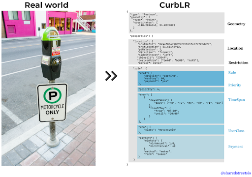
Translating a physical, real world asset into a data standard
CurbLR balances flexibility and structure that enables it to adapt to the curb peculiarities of different cities while providing a framework for interoperability across cities. Azavea converted CCD’s raw data into a CurbLR-compliant format that makes it easier to visualize and generate statistics. For example, it’s now easy to calculate and visualize the 50% increase in free parking spots at 9 am on Sunday compared to Monday.
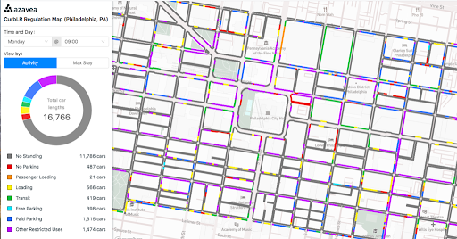
Screenshot of the interactive map showing the curb data: https://demos.azavea.com/phila-curb-map/
Benefits of CurbLR
Improved urban planning: Improved data access can help cities and private companies make better decisions and use shared resources more efficiently. Outcomes could include improved parking flow and reduced traffic. As Donald Shoup writes in The High Cost of Free Parking, “because curb parking is underpriced and overcrowded in the busiest parts of most of the world’s big cities, the sun never sets on cruising.“ Better data on the curb could help planners implement more informed regulations. Data standards would also facilitate comparisons across cities.
The public benefits when data is openly available. Private companies are already offering proprietary data services to cities that promote their own infrastructure and standards. This leads to vendor lock-in. We see CurbLR as the curb equivalent to the General Transit Feed Specification (GTFS), which was a boon to cities and the public. GTFS started out as a side project in 2005 because there was no standard at the time, but it is now adopted by thousands of public transit providers globally. This makes it easier for software developers to build an ecosystem of tools that benefit everyone.
Generating the data
The Center City District provided Azavea raw data from street surveys. We developed a small software library that consumes the data and generates outputs in the CurbLR format. This blog on Azavea.com describes the data analysis in much more detail.
What do we hope is next for CurbLR?
Data standards become more useful the more they are used and implemented. We are grateful to both Center City District and SharedStreets to have the opportunity to work at the cutting edge of a new standard. We believe CurbLR has tremendous potential to become the standard used for maintaining curb data in cities across the world. This would make cross-city scalability easier for companies that interact with the curb, for example, rideshares like Uber and Lyft, along with companies that promote improved parking access like Passport Parking and SpotHero.
We’d like to see:
-
More cities engage in CurbLR pilot projects
-
Improvements in the SharedStreets CLI tool along with suggestions for dealing with unmatched and mismatched street segments.
-
Further tooling that makes it easier to update and manage CurbLR data. This could be a desktop GIS plugin (ArcMap or QGIS) or a simple web interface.
Questions or comments? Azavea would love to hear from you! Feel free to reach out: info@azavea.com or learn more about Azavea’s work.
Ross Bernet is a project manager at Azavea. He is interested in how data can be used to improve our cities.
.(JavaScript must be enabled to view this email address)

