It’s no secret that redlining shaped the economic and racial disparities on display in U.S. cities today. But the extent to which the notorious red “hazardous” zones — the source of the term “redlining” — depicted by Home Owners Loan Corporation (HOLC) maps in the 1930s overlap with current neighborhood-level economic and racial data is still arresting. In fact, three out of four neighborhoods marked in red on the federal agency’s maps 80 years ago are still struggling economically, according to a new study from the National Community Reinvestment Coalition (NCRC).
The HOLC maps, which were digitized by the Mapping Inequality project in 2016, were created by government surveyors to document which neighborhoods local lenders considered “risky”. Their overarching goal, as Next City has covered, was to guide lenders making residential loans in the wake of the Great Depression. But while they considered things like access to transportation and quality of housing, a key driver of their system for assessing the risk of lending to any given neighborhood was the racial and ethnic makeup of each neighborhood’s residents.
NCRC compared the HOLC grading of 115 cities with data including each city’s median family income (classifying it as either low-to-moderate, or middle-to-upper) and the numbers of non-Hispanic white people in each census tract (classifying the tracts as either majority-white, or majority-minority). They also looked at patterns of gentrification with a subset of 30 cities — examining neighborhoods where educational attainment and median home value increased sharply from 2000 to 2010.
The overlaps are stark.
“Most of the neighborhoods (74 percent) that the HOLC graded as high-risk, or ‘hazardous’ eight decades ago are low-to-moderate income (LMI) today,” researchers state. “Additionally, most of the HOLC graded ‘hazardous’ areas (nearly 64 percent) are minority neighborhoods now.”
The enduring legacy of redlining is particularly apparent in the 10 cities containing the most neighborhoods graded “hazardous” — which today remain hyper segregated — according to the NCRC.

(Credit: NCRC)
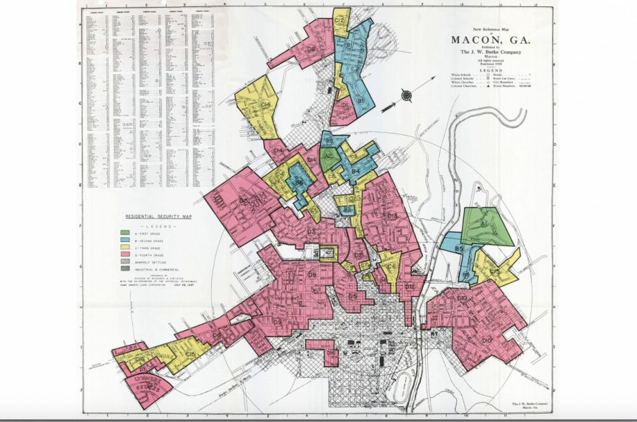
“Eight of those cities were in the South, including Macon, Georgia, the most redlined city in America,” the report’s overview states. “In Macon, 65 [percent] of neighborhoods were deemed “hazardous” and unworthy of credit. Today, 1 in 4 residents of Macon County are still below the poverty line, and that rate is 2.5 times higher among black residents.”
The pattern is region-wide.
“Cities in the South showed the least change in the HOLC-evaluated ‘hazardous’ neighborhoods that today have lower incomes and higher populations of majority-minority residents,” the report states. “The Midwest closely followed the South in the persistence of low-to-moderate income (LMI) neighborhoods and HOLC ‘hazardous’ areas.”
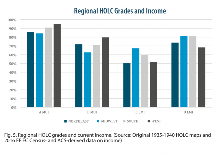
(Credit: NCRC)
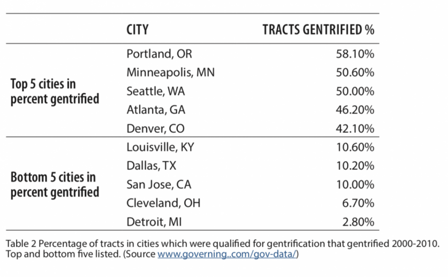
But that doesn’t necessarily mean cities in other regions are more equitable. Cities in the west are still highly segregated, according to the report, but that segregation isn’t associated with quite as much economic discrepancy. And several of the cities with the highest levels of gentrification (Seattle, Portland, Denver) are in the west — and those 10-year changes come with their own version of economic inequality.
(Credit: NCRC)
Overall, the research demonstrates again — in hard numbers — that the racial wealth gap is not some kind of accidental phenomena, but comes from intentional policies. There’s some question as to whether HOLC itself can be held completely responsible for its “hazardous” zones (or whether it was simply chronicling a patchwork of regional practices already in existence). Regardless, as Amy Hillier, a professor of social policy, told Next City for a story published last year: “Systemic disinvestment between the federal government, private sector and individual citizens caused long-term damage, in particular to urban neighborhoods of color.”
Or, in the words of Jason Richardson, Director of Research at NCRC: “It’s as if time stood still in some of these places, locking people into neighborhoods of concentrated poverty.”

Rachel Dovey is an award-winning freelance writer and former USC Annenberg fellow living at the northern tip of California’s Bay Area. She writes about infrastructure, water and climate change and has been published by Bust, Wired, Paste, SF Weekly, the East Bay Express and the North Bay Bohemian
Follow Rachel .(JavaScript must be enabled to view this email address)

_920_614_600_350_80_s_c1.jpg)
_600_350_80_s_c1.JPG)

